An-illustration-of-height-measurement-using-satellite-altimetry.jpg (478 × 540 pixels, file size: 72 KB, MIME type: image/jpeg)
Summary
Summary
| This image was uploaded in a raster graphics format such as PNG, GIF, or JPEG. However, it contains information that could be stored more efficiently and/or accurately in the SVG format, as a vector graphic. If possible, please upload an SVG version of this image. After confirming it is of comparable quality, please replace all instances of the previous version throughout OODA WIKI (noted under the "File links" header), tag the old version with {{Vector version available|NewImage.svg}}, and remove this tag. For more information, see OODA WIKI:Preparing images for upload. For assistance with converting to SVG, please see the Graphics Lab.Do not re-draw or auto-trace non-free images; instead, seek out vector versions from official sources. |  |
| Description |
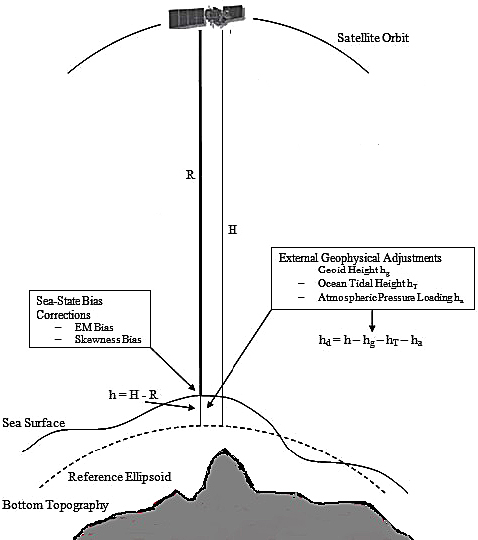
English: An illustration of height measurement using satellite altimetry. |
|---|---|
| Source |
Z. N. Musa et. al. "A review of applications of satellite SAR, optical, altimetry and DEM data for surface water modelling, mapping and parameter estimation ", Hydrology and Earth System Sciences doi:10.5194/hess-19-3755-2015 |
| Date |
2015-09-01 |
| Author |
Z. N. Musa, A. Mynett |
| Permission (Reusing this file) |
This work is licensed under a Creative Commons Attribution 3.0 Unported License. To view a copy of this license, visit https://creativecommons.org/licenses/by/3.0/
|
==Licensing==
| This work is licensed under the Creative Commons Attribution 3.0 License. |
File history
Click on a date/time to view the file as it appeared at that time.
| Date/Time | Thumbnail | Dimensions | User | Comment | |
|---|---|---|---|---|---|
| current | 09:43, 30 January 2024 | | 478 × 540 (72 KB) | Isidore (talk | contribs) | =={{int:filedesc}}== {{Convert to SVG}} {{Information |description={{en|1=An illustration of height measurement using satellite altimetry. }} |date=2015-09-01 |source=Z. N. Musa et. al. "A review of applications of satellite SAR, optical, altimetry and DEM data for surface water modelling, mapping and parameter estimation ", Hydrology and Earth System Sciences [https://dx.doi.org/10.5194/hess-19-3755-2015 doi:10.5194/hess-19-3755-2015] |author=Z. N. Musa, A. Mynett |permission=This work is li... |
You cannot overwrite this file.
File usage
The following page uses this file: