No higher resolution available.
CapeCodCanalEastEndAerial.jpg (270 × 365 pixels, file size: 16 KB, MIME type: image/jpeg)
Summary
Summary
| Description |
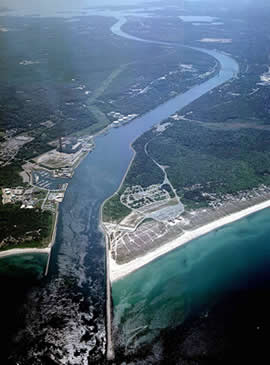
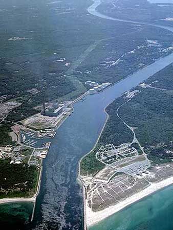
English: Aerial photo of the East End of the Cape Cod Canal and Scusset Beach State Reservation in southeastern Massachusetts, USA. |
|---|---|
| Source |
http://www.nae.usace.army.mil/recreati/ccc/recreation/recreation.htm |
| Date | |
| Author |
U.S. Army Corps of Engineers |
| Permission (Reusing this file) |
See below. |
| Other versions | http://www.nae.usace.army.mil/Portals/74/siteimages/Recreation/CCC/Web-site-photos/010827-A-KF207-001.JPG?ver=2016-12-22-133017-940 |
- REDIRECT Target page name
Licensing
File history
Click on a date/time to view the file as it appeared at that time.
| Date/Time | Thumbnail | Dimensions | User | Comment | |
|---|---|---|---|---|---|
| current | 10:14, 26 March 2024 | | 270 × 365 (16 KB) | Isidore (talk | contribs) | == {{int:filedesc}} == {{Information |Description={{en|1=Aerial photo of the East End of the Cape Cod Canal and Scusset Beach State Reservation in southeastern Massachusetts, USA.}} |Source=http://www.nae.usace.army.mil/recreati/ccc/recreation/recreation.htm |Author=U.S. Army Corps of Engineers |Date= |Permission= |other_versions=http://www.nae.usace.army.mil/Portals/74/siteimages/Recreation/CCC/Web-site-photos/010827-A-KF207-001.JPG?ver=2016-12-22-133017-940 }} {{Location|41.781553|-70.48244... |
You cannot overwrite this file.
File usage
The following page uses this file: