Original file (1,280 × 565 pixels, file size: 130 KB, MIME type: image/png)
Summary
Summary
| Description |
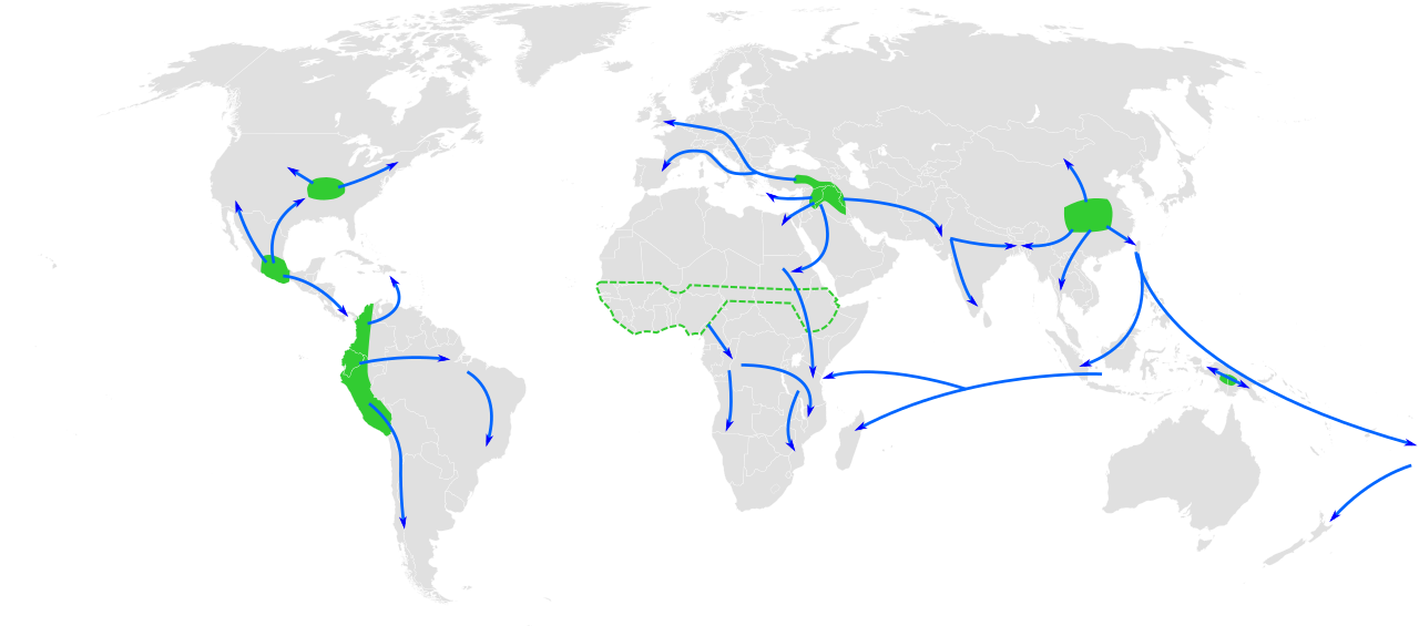
[Map of the world showing approximate centres of origin of agriculture and its spread in prehistory: eastern USA (4000-3000 BP), Central Mexico (5000-4000 BP), Northern South America (5000-4000 BP), sub-Saharan Africa (5000-4000 BP, exact location unknown), the Fertile Crescent (11000 BP), the Yangtze and Yellow River basins (9000 BP) and the New Guinea Highlands (9000-6000 BP). A proposed centre of origin in Amazonia (Lathrap 1977) is not shown. Adapted from File:BlankMap-World6, compact.svg and Diamond, J.; Bellwood, P. (2003). "Farmers and Their Languages: The First Expansions". Science. 300: 597–603. doi:10.1126/science.1078208. |
|---|---|
| Source |
Own work |
| Date |
2010-11-29 |
| Author | |
| Permission (Reusing this file) |
See below.
|
Licensing
I, the copyright holder of this work, hereby publish it under the following licenses:
You may select the license of your choice.
|


File history
Click on a date/time to view the file as it appeared at that time.
| Date/Time | Thumbnail | Dimensions | User | Comment | |
|---|---|---|---|---|---|
| current | 17:30, 25 November 2023 | | 1,280 × 565 (130 KB) | Isidore (talk | contribs) | == {{int:filedesc}} == {{Information |Description={{en|1=Map of the world showing approximate centres of origin of agriculture and its spread in prehistory: eastern USA (4000-3000 BP), Central Mexico (5000-4000 BP), Northern South America (5000-4000 BP), sub-Saharan Africa (5000-4000 BP, exact location unknown), the Fertile Crescent (11000 BP), the Yangtze and Yellow River basins (9000 BP) and the New Guinea Highlands (9000-6000 BP). A proposed centre of origin in Amaz... |
You cannot overwrite this file.
File usage
The following page uses this file: