ConstellationGPS.gif (240 × 192 pixels, file size: 485 KB, MIME type: image/gif, looped, 300 frames, 30 s)
Note: Due to technical limitations, thumbnails of high resolution GIF images such as this one will not be animated.
Summary
Summary
| Description |
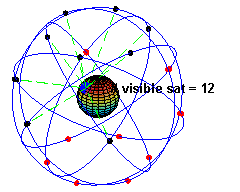
English: A simulation of the original design of the GPS space segment, with 24 GPS satellites (4 satellites in each of 6 orbits), showing the evolution of the number of visible satellites from a fixed point (45°N) on earth (considering "visibility" as having direct line of sight). The parameters used to simulate the orbits are: eccentricity (e) 0.05, inclination (i) 55° and a separation between orbits of 60° in the right ascension of the ascending node. Within each orbit, the four satellites are evenly spaced (the instant of pass through perihelion being arbitrary for the first satellite in each orbit). The orbital period of the satellites was taken to be 12 hours. The earth was considered a perfect sphere with a radius of 6400 km. The time in the animation is running about 2880 times faster than real time (half a minute representing 24 hours), as clearly seen in the rotation of earth. The simulation was created using MATLAB and converted to animated gif format using Adobe ImageReady. |
|---|---|
| Source | |
| Date | |
| Author | |
| Permission (Reusing this file) |
See below.
|
Template:Created with MATLAB Template:Media of the day
Licensing
⧼wm-license-original-upload-log⧽
Template:Original description page
- 2007-12-09 17:51 El pak 240×192×8 (497149 bytes) A simulation of the original design of the GPS space segment, with 24 GPS satellites (4 satellites in each of 6 orbits), showing the evolution of the number of visible satellites from a fixed point (45ºN) on earth (considering "visibility" as having dire
- 2007-12-07 01:41 El pak 316×272×10 (1186667 bytes) A simulation of the 24 GPS satellites (4 satellites in each of 6 orbits), including the evolution of the number of visible satellites from a fixed point (45ºN) on earth (considering "visibility" as having direct line of sight)
File history
Click on a date/time to view the file as it appeared at that time.
| Date/Time | Thumbnail | Dimensions | User | Comment | |
|---|---|---|---|---|---|
| current | 16:52, 20 January 2024 | | 240 × 192 (485 KB) | Isidore (talk | contribs) | == {{int:filedesc}} == {{Information |Description={{en|A simulation of the original design of the GPS space segment, with 24 GPS satellites (4 satellites in each of 6 orbits), showing the evolution of the number of visible satellites from a fixed point (45°N) on earth (considering "visibility" as having direct line of sight). The parameters used to simulate the orbits are: eccentricity (e) 0.05, inclination (i) 55° and a separation between orbits of 60° in the right ascension of the ascendin... |
You cannot overwrite this file.
File usage
The following page uses this file: