
Size of this PNG preview of this SVG file: 400 × 600 pixels. Other resolution: 1,365 × 2,048 pixels.
Original file (SVG file, nominally 512 × 768 pixels, file size: 43 KB)
Summary
Summary
| Description |
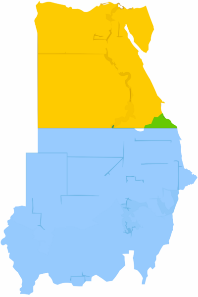
English: Simplified map showing Egypt's claim (yellow and green), Sudan's claim (blue and green), the Hala'ib Triangle (light green), Wadi Halfa Salient (dark green) and Bir Tawil (white). |
|---|---|
| Source | |
| Date |
2013-01-11 21:18 (UTC) |
| Author | |
| Permission (Reusing this file) |
See below.
|
Licensing
| This work is licensed under the Creative Commons Attribution-ShareAlike 3.0 License. |
⧼wm-license-original-upload-log⧽
This image is a derivative work of the following images:
- File:Political_Regions_of_Sudan,_July_2010.svg licensed with Cc-zero
- File:Egypt_location_map.svg licensed with Cc-by-sa-3.0, GFDL
- 2011-04-17T16:03:10Z NordNordWest 1055x973 (359140 Bytes) upd
- 2010-03-07T17:03:18Z NordNordWest 1055x973 (566369 Bytes) resize
- 2009-09-03T10:48:31Z NordNordWest 1055x956 (565065 Bytes)
- 2009-05-23T19:10:12Z NordNordWest 1056x959 (570357 Bytes) corr
- 2008-08-10T11:12:09Z NordNordWest 1056x957 (503154 Bytes) {{Information |Description= {{de|Positionskarte von [[:de:Ägypten|Ägypten]]}} Quadratische Plattkarte, N-S-Streckung 110 %. Geographische Begrenzung der Karte: * N: 32.1° N * S: 21.3° N * W: 24.2° O * O: 37.3° O {{en|Lo
File history
Click on a date/time to view the file as it appeared at that time.
| Date/Time | Thumbnail | Dimensions | User | Comment | |
|---|---|---|---|---|---|
| current | 11:14, 7 February 2024 | | 512 × 768 (43 KB) | Isidore (talk | contribs) | == {{int:filedesc}} == {{Information |description={{en|1=Simplified map showing Egypt's claim (yellow and green), Sudan's claim (blue and green), the Hala'ib Triangle (light green), Wadi Halfa Salient (dark green) and Bir Tawil (white).}} |source={{Derived from|Political_Regions_of_Sudan,_July_2010.svg|Egypt_location_map.svg|display=50}} |date=2013-01-11 21:18 (UTC) |author=*{{F|Political_Regions_of_Sudan,_July_2010.svg|+}}: {{U|Node ue}} *{{F|Egypt_location_map.svg|+}}: {{U|NordNordWest}} *{... |
You cannot overwrite this file.
File usage
The following page uses this file: