
Original file (1,024 × 681 pixels, file size: 134 KB, MIME type: image/jpeg)
Summary
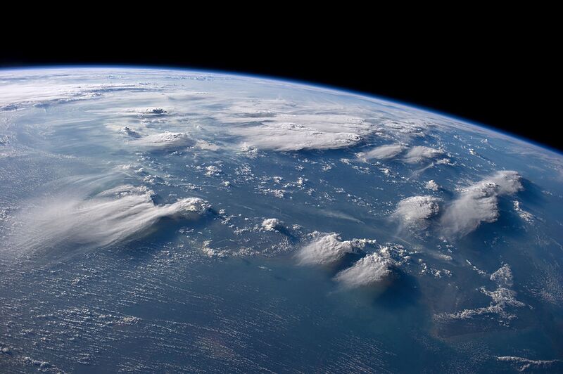
English: Thunderheads near Borneo, Indonesia are featured in this image photographed by an Expedition 40 crew member on the International Space Station. Crews aboard the International Space Station (ISS) have recently focused their cameras on panoramic views of clouds. Many of the photographs have been taken with lenses similar to the focal length of the human eye. Such images help us see Earth the way ISS crews see it from their perch 350 kilometers above—with a strong three-dimensional sense and a broad view of the planet. In this image, late afternoon sunlight casts long shadows from thunderhead anvils down onto southern Borneo. Near the horizon (image top center), more than 1000 kilometers away from the space station, storm formation is assisted by air currents rising over the central mountains of Borneo. Winds usually blow in different directions at different altitudes. At the time of this photo, high-altitude winds were clearly sweeping the tops off the many tallest thunderclouds, generating long anvils of diffuse cirrus plumes that trail south. At lower levels of the atmosphere, “streets” of white dots—fair-weather cumulus clouds—are aligned with west-moving winds. Small smoke plumes from forest fires in Borneo are also aligned west. Caption by M. Justin Wilkinson, Jacobs and Michael Trenchard, Barrios Technology at NASA-JSC Українська: Грозові хмари біля острову Калімантан, Індонезія, зняті екіпажем МКС-40 Міжнародної космічної станції в День Землі. Deutsch: Gewitterwolken nahe Borneo am Tag der Erde. Thematischer Schwerpunkt dieses Bildes ist Indonesien. Die Fotografie wurde von einem Mitglied der Expedition 40 der Internationalen Raumstation (ISS) aufgenommen. Date 5 August 2014 Source http://earthobservatory.nasa.gov/IOTD/view.php?id=84308&src=ve https://www.flickr.com/photos/nasa2explore/14991571998/ Author NASA/Expedition 40 crew member Camera location 4° 36′ 00″ S, 113° 06′ 00″ E Heading=0° Kartographer map based on OpenStreetMap. View this and other nearby images on: OpenStreetMap
Licensing
| This file is in the public domain, because (no reason given!)
Please verify that the reason given above is valid! Note: if there is a specific licence tag for the reason supplied here, please use it. |
File history
Click on a date/time to view the file as it appeared at that time.
| Date/Time | Thumbnail | Dimensions | User | Comment | |
|---|---|---|---|---|---|
| current | 13:07, 28 September 2023 | | 1,024 × 681 (134 KB) | Isidore (talk | contribs) | English: Thunderheads near Borneo, Indonesia are featured in this image photographed by an Expedition 40 crew member on the International Space Station. Crews aboard the International Space Station (ISS) have recently focused their cameras on panoramic views of clouds. Many of the photographs have been taken with lenses similar to the focal length of the human eye. Such images help us see Earth the way ISS crews see it from their perch 350 kilometers above—with a strong three-dimensional sens... |
You cannot overwrite this file.
File usage
The following page uses this file: