
Original file (567 × 768 pixels, file size: 252 KB, MIME type: image/jpeg)
Summary
| Description |
Lua error in Module:Unicode_data at line 15: attempt to call field 'length' (a nil value). |
|---|---|
| Source |
Aeronautical Information Publication - Domestic (AIP) of the Israel Civil Aviation Administration – presently Civil Aviation Authority (CAA) |
| Date |
2009-10-11 |
| Author |
Etan Tal |
| Permission (Reusing this file) |
|
Image to be used for illustration of aviation articles. Not for actual navigation. Original image is public domain (State Regulations) - uploader added the disclaimers prohibiting navigation use in compliance with normal aviation practice. Modified image released to the public domain as well.
File history
Click on a date/time to view the file as it appeared at that time.
| Date/Time | Thumbnail | Dimensions | User | Comment | |
|---|---|---|---|---|---|
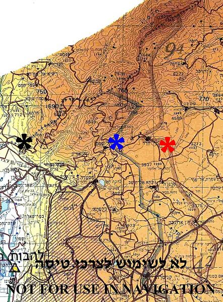
| current | 11:42, 7 February 2024 | | 567 × 768 (252 KB) | Isidore (talk | contribs) | {{Information |Description={{en|1=Borders between Israel, Syria and Lebanon in Mount Hermon region The (+++) line between Israel and Lebanon – marked by black asterisk Disengagement Israeli front line with Syria (1974) - marked by blue asterisk Disengagement Syrian front line with Israel (1974) - marked by red asterisk. }} |Source=Aeronautical Information Publication - Domestic (AIP) of the Israel Civil Aviation Administration – presently Civil Aviation Authority (CAA) |Author=Etan Tal... |
You cannot overwrite this file.
File usage
The following page uses this file: