No higher resolution available.
Map-antarctica-ross-ice-shelf-red-x.png (316 × 313 pixels, file size: 26 KB, MIME type: image/png)
Summary
| Description |
|
|---|---|
| Source | |
| Date |
2009-02-16 17:20 (UTC) |
| Author |
|
| Permission (Reusing this file) |
See below. |
| Other versions | Template:DerivativeVersions |
⧼wm-license-original-upload-log⧽
This image is a derivative work of the following images:
- File:Antarctica_Map.png licensed with PD-USGov-CIA-WF
- 2004-12-15T23:16:35Z Mschlindwein 502x617 (53433 Bytes)
File history
Click on a date/time to view the file as it appeared at that time.
| Date/Time | Thumbnail | Dimensions | User | Comment | |
|---|---|---|---|---|---|
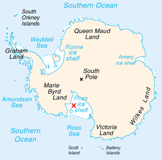
| current | 11:36, 7 February 2024 | | 316 × 313 (26 KB) | Isidore (talk | contribs) | {{Information |Description=*Map of Antarctica with a red X on the Ross Ice Shelf. |Source=*Antarctica_Map.png |Date=2009-02-16 17:20 (UTC) |Author=*Antarctica_Map.png *derivative work: -- Jeandré, 2009-02-16t17:22z |Permission= |other_versions={{DerivativeVersions|Antarctica map indicating Antarctic Peninsula.JPG}} }} {{RetouchedPicture|Cropped, put in red X o... |
You cannot overwrite this file.
File usage
The following page uses this file: