
Original file (SVG file, nominally 2,050 × 1,213 pixels, file size: 502 KB)
Summary
Summary
| Description |
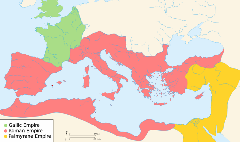
English: Map of the Roman Empire around the year of the consulship of Aurelianus and Bassus (271 AD), with the break away Gallic Empire in the West and the Palmyrene Empire in the East. |
|---|---|
| Source | |
| Date |
2009-02-26 04:12 (UTC) |
| Author |
|
| Permission (Reusing this file) |
|
| Other versions | Template:Other versions/Map of Ancient Rome 271 AD |
Template:Atelier graphique carte Template:Translation possible
Licensing
⧼wm-license-original-upload-log⧽
Template:Original description page
- 2007-11-07 02:47 Justinian43 524×377×8 (26490 bytes) The Mediterranean by 271 A.D -The [[Roman Empire]]. -The breakaway [[Gallic Empire]]. -The breakaway [[Palmyrene Empire]].
- derivative work: Pomalee (talk)
other_versions=Template:DerivativeVersions Permission= GNU Free Documentation License, Version 1.2, Creative Commons Attribution-ShareAlike license versions 3.0, 2.5, 2.0, and 1.0
- Romanworld271AD.jpg: User:Justinian43, uploaded by User:El_bes
 | Permission is granted to copy, distribute and/or modify this document under the terms of the GNU Free Documentation License, Version 1.2 or any later version published by the Free Software Foundation; with no Invariant Sections, no Front-Cover Texts, and no Back-Cover Texts. |
Template:License migration complete
⧼wm-license-original-upload-log⧽
This image is a derivative work of the following images:
- File:Blank_map_of_South_Europe_and_North_Africa.svg licensed with Cc-by-sa-2.5,2.0,1.0, GFDL
- 2007-08-09T20:26:49Z Historicair 2050x1213 (1260388 Bytes)
- 2007-08-09T16:12:00Z Historicair 2050x1213 (351130 Bytes) {{Improving}} {{Information |Description={{fr}}Carte vierge de l'Europe du Sud et du Bassin Méditerranée dans l'Antiquité {{en}}Blank map of South Europe and North Africa at Antic period |Source=Own work + [[Image:Blank map of South Europe and North Africa.svg]] by myself
- File:Romanworld271AD.jpg licensed with GFDL-en
- 2007-11-20T15:23:56Z El bes 524x377 (26490 Bytes) {{Information |Description= The Roman Empire around the year 271 AD, with the break awai Gallic Empire in the West |Source= http://en.wikipedia.org/wiki/Image:Romanworld271AD.JPG |Date= November 20th, 2007 |Author= [[http://e
File history
Click on a date/time to view the file as it appeared at that time.
| Date/Time | Thumbnail | Dimensions | User | Comment | |
|---|---|---|---|---|---|
| current | 17:20, 15 March 2024 | | 2,050 × 1,213 (502 KB) | Isidore (talk | contribs) | == {{int:filedesc}} == {{Information |Description={{en|Map of the Roman Empire around the year of the consulship of Aurelianus and Bassus (271 AD), with the break away Gallic Empire in the West and the Palmyrene Empire in the East.}} |Source=*Blank map of South Europe and North Africa.svg *Romanworld271AD.jpg |Date=2009-02-26 04:12 (UTC) |Author=*[[:File:Blank_map_of_South_Europe_and_North_Africa.svg|Blank... |
You cannot overwrite this file.
File usage
The following 2 pages use this file: