
Original file (SVG file, nominally 912 × 653 pixels, file size: 346 KB)
Summary
Summary
| Description |
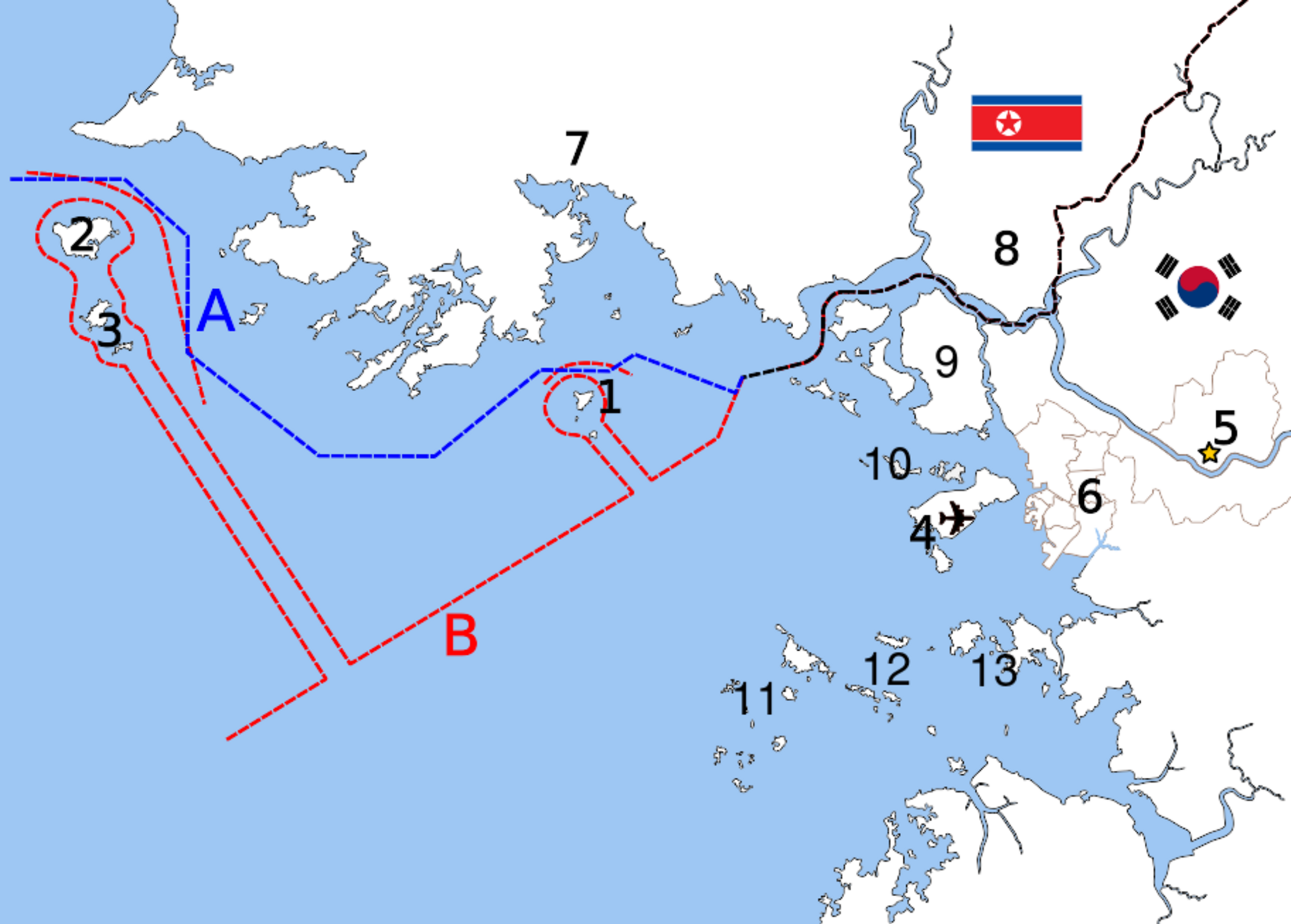
English: Map of Korean maritime border, language neutral version. #Yeonpyeong Island #Baengnyeong Island #Daecheong Island and Socheong Island #Yeongjong Island (Incheon Intl. Airport) #Seoul #Incheon #Haeju #Kaesong #Ganghwa County #Bukdo-myeon #Deokjeok-myeon #Jawol-myeon #Yeongheung-myeon *A. Northern Limit Line (NLL, the border claimed by South Korea since 1953) *B. Military Demarcation Line (the border claimed by North Korea since 1999) Template:Ko Template:Pl Template:Zh-hans Template:Zh-hant Template:De Template:Fr |
|---|---|
| Source |
Based on File:Inchon islands 2.svg (by Amble) and File:朝韩争议区(延坪岛附近).svg (by 玖巧仔). Modified and converted to language neutral version by Tomchen1989. Flags are from File:Flag of South Korea.svg and File:Flag of North Korea.svg which are in the public domain. The Northern Limit Line and the Military Demarcation Line are according to Xinhua and NYTimes; compare Jon M. Van Dyke, Mark J. Valencia, Jenny Miller Garmendia. "The North/South Korea Boundary Dispute in the Yellow (West) Sea," . Marine Policy 27 (2003), 143-158, 144; excerpt, "Fig. 1. North/South Korea Maritime Border Area in the Yellow (West) Sea (Sources: Map of Maritime Boundaries compiled by Beckee Morrison based on North Korean MDL declaration as reported in "Koreas' North rejects maritime border with South in West Sea," Central Broadcasting Station, September 2, 1999; South Korean Defense Department reconstruction in Chosun Daily News, July 7, 2002; Ministry of National Defense, The Republic of Korea Position Regarding the Northern Limit Line, August 2002; "North Korea issues communiqué on navigation around Yellow Sea islands," Central Broadcasting Station, March 23, 2000." |
| Date |
2010-11-25 |
| Author |
See above |
| Permission (Reusing this file) |
|
Licensing
| This work is licensed under the Creative Commons Attribution-ShareAlike 3.0 License. Attribution: Amble, 玖巧仔 and Tomchen1989 |
File history
Click on a date/time to view the file as it appeared at that time.
| Date/Time | Thumbnail | Dimensions | User | Comment | |
|---|---|---|---|---|---|
| current | 09:59, 7 February 2024 | | 912 × 653 (346 KB) | Isidore (talk | contribs) | == {{int:filedesc}} == {{Information |Description= {{en|1=Map of Korean maritime border, language neutral version. #Yeonpyeong Island #Baengnyeong Island #Daecheong Island and Socheong Island #Yeongjong Island (Incheon Intl. Airport) #Seoul #Incheon #Haeju #Kaesong #Ganghwa County #[[:en:Ongjin County#Admini... |
You cannot overwrite this file.
File usage
The following page uses this file: