Map_of_the_Ancient_Rome_at_Caesar_time_(with_conquests)-en.png (640 × 389 pixels, file size: 402 KB, MIME type: image/png)
Summary
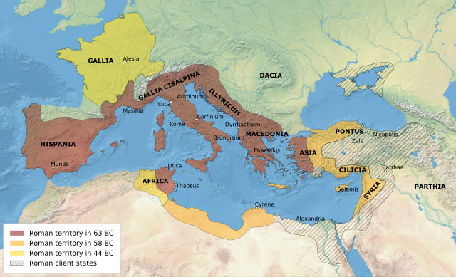
Map of the Roman Republic's empire and vassal states, 1st century BC. All labels in Latin. Legend in English. Date 28 April 2022 Source Own work based on: Map of the Ancient Rome at Caesar time (with conquests)-fr.svg Author User:Historicair, Ifly6 Other versions [edit] Attention page editors: please review Module:Multilingual description/sort and add your language in the correct order. Thank you! This file is licensed under the Creative Commons Attribution-Share Alike 3.0 Unported license.
Licensing
| This work is licensed under the Creative Commons Attribution-ShareAlike 2.5 License. |
File history
Click on a date/time to view the file as it appeared at that time.
| Date/Time | Thumbnail | Dimensions | User | Comment | |
|---|---|---|---|---|---|
| current | 08:30, 28 September 2023 | | 640 × 389 (402 KB) | Isidore (talk | contribs) | Map of the Roman Republic's empire and vassal states, 1st century BC. All labels in Latin. Legend in English. Date 28 April 2022 Source Own work based on: Map of the Ancient Rome at Caesar time (with conquests)-fr.svg Author User:Historicair, Ifly6 Other versions [edit] Attention page editors: please review Module:Multilingual description/sort and add your language in the correct order. Thank you! This file is licensed under the Creative Commons Attribution-Share Alike 3.0 Unported license. |
You cannot overwrite this file.
File usage
The following page uses this file:
-en.png&oldid=3219)