Size of this preview: 800 × 566 pixels. Other resolution: 1,004 × 710 pixels.
Original file (1,004 × 710 pixels, file size: 233 KB, MIME type: image/jpeg)
Summary
Summary
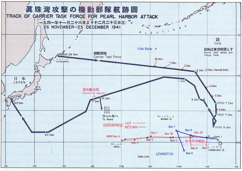
Template:Es[The route of the Japanese flotilla (Kido Butai), with the USS Enterprise (in red) and the USS Lexington (in blue) to the South.] Error: {{Lang-xx}}: text has italic markup (help) Public Domain chart from "Reports of General MacArthur, prepared by his General Staff." This book was printed by GPO. The chart shows the routes of the Japanese attack force to and from Pearl Harbor. I have added the routes of the two American carriers. Template:PD-USGov
Licensing
| This file is in the public domain, because (no reason given!)
Please verify that the reason given above is valid! Note: if there is a specific licence tag for the reason supplied here, please use it. |
File history
Click on a date/time to view the file as it appeared at that time.
| Date/Time | Thumbnail | Dimensions | User | Comment | |
|---|---|---|---|---|---|
| current | 22:15, 5 December 2023 | | 1,004 × 710 (233 KB) | Isidore (talk | contribs) | == {{int:filedesc}} == {{es|La flota Japonesa se movilizó sin ser detectada rumbo a Pearl Harbor.}}{{en|The route of the Japanese flotilla (''Kido Butai''), with the ''USS Enterprise'' (in red) and the ''USS Lexington'' (in blue) to the South.}} Public Domain chart from "Reports of General MacArthur, prepared by his General Staff." This book was printed by GPO. The chart shows the routes of the Japanese attack force to a... |
You cannot overwrite this file.
File usage
The following page uses this file: