
Original file (844 × 762 pixels, file size: 44 KB, MIME type: image/png)
Summary
Summary
| Description |
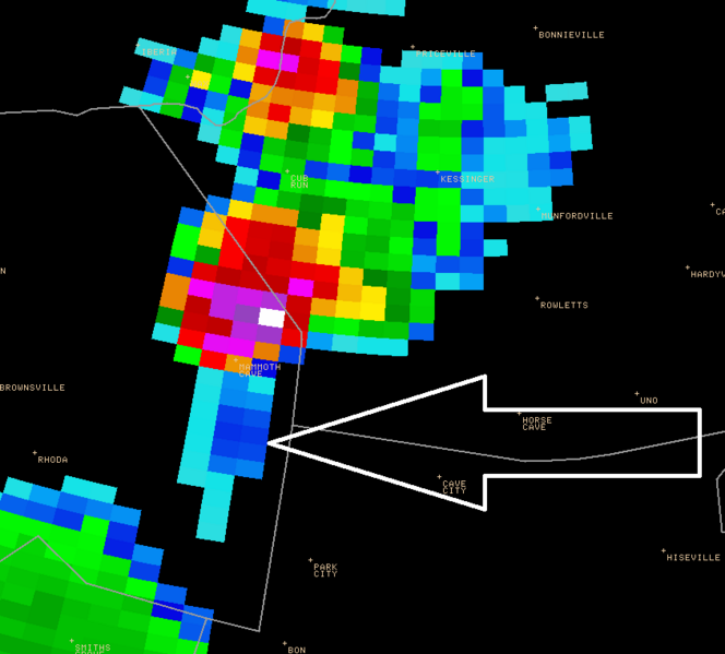
English: A three body scatter spike is seen here on the weather radar data south of thunderstorm near Mammoth Cave. This feature has been shown to be associated with very large hail within thunderstorms. The radar image here was taken at 2:38 PM EDT at an altitude of about 20,000 feet, and about 19 minutes later one inch diameter hail was reported in Kessinger in Hart County. The arrow point to the feature Template:Fr |
|---|---|
| Source |
Image from the web page 14 June 2005 central Kentucky and southern Indiana Damaging Winds and Large Hail |
| Date |
2005-06-14 |
| Author |
National Weather Service in Louisville, KY |
| Permission (Reusing this file) |
See below.
|
Licensing
| This file is in the public domain, because (no reason given!)
Please verify that the reason given above is valid! Note: if there is a specific licence tag for the reason supplied here, please use it. |
File history
Click on a date/time to view the file as it appeared at that time.
| Date/Time | Thumbnail | Dimensions | User | Comment | |
|---|---|---|---|---|---|
| current | 16:40, 24 March 2024 | | 844 × 762 (44 KB) | Isidore (talk | contribs) | == {{int:filedesc}} == {{Information |Description={{en|1=A three body scatter spike is seen here on the weather radar data south of thunderstorm near Mammoth Cave. This feature has been shown to be associated with very large hail within thunderstorms. The radar image here was taken at 2:38 PM EDT at an altitude of about 20,000 feet, and about 19 minutes later one inch diameter hail was reported in Kessinger in Hart County. The arrow point to the feature}} {{fr|1=Un écho caractéristique de réf... |
You cannot overwrite this file.
File usage
The following page uses this file: