US_Overflight_Fee_Map.png (375 × 272 pixels, file size: 28 KB, MIME type: image/png)
Summary
Summary
| Description |
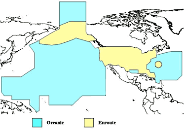
English: A map of the regions where the United States charges overflight fees. Yellow is where higher "enroute" fees are charged. Blue is where "oceanic" fees are charged. The colored regions of this map correspond to the regions where the US has delegated authority by the ICAO to control air traffic, including over international waters. |
|---|---|
| Source |
http://www.faa.gov/about/office_org/headquarters_offices/aba/overflight_fees/ |
| Date |
style="background: #EEE; font-size: smaller; vertical-align: middle; text-align: center; " class="unknown table-unknown"|date |
| Author | |
| Permission (Reusing this file) |
See below.
|
Licensing
| This file is in the public domain, because (no reason given!)
Please verify that the reason given above is valid! Note: if there is a specific licence tag for the reason supplied here, please use it. |
File history
Click on a date/time to view the file as it appeared at that time.
| Date/Time | Thumbnail | Dimensions | User | Comment | |
|---|---|---|---|---|---|
| current | 19:14, 15 January 2024 | | 375 × 272 (28 KB) | Isidore (talk | contribs) | =={{int:filedesc}}== {{Information |description={{en|1=A map of the regions where the United States charges overflight fees. Yellow is where higher "enroute" fees are charged. Blue is where "oceanic" fees are charged. The colored regions of this map correspond to the regions where the US has delegated authority by the ICAO to control air traffic, including over international waters.}} |date={{unknown|date}} |source=http://www.faa.gov/about/office_org/headquarters_offices/aba/overflight_fees/... |
You cannot overwrite this file.
File usage
The following page uses this file: