World_ocean_map.gif (500 × 500 pixels, file size: 68 KB, MIME type: image/gif, looped, 4 frames, 10 s)
Summary
Summary
| Description |
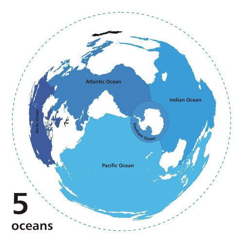
English: Animated map exhibiting the world's oceanic waters. A continuous body of water encircling Earth, the World Ocean is divided into a number of principal areas with relatively uninhibited interchange among them. Five oceanic divisions are usually defined: Pacific, Atlantic, Indian, Arctic, and Southern; the last two listed are sometimes consolidated into the first three. Animated world ocean map (GIF), exhibiting various oceans. Azimuthal distance projection map is based on world map from this online Java tool by Henry Bottomley and altered using CorelDraw/PhotoPaint, et al. Map is centered on 85° W, 45° S, rotated 90° CCW (North Pole is to the left). Ocean boundaries per International Hydrographic Organisation. * blue: ocean * black: other substantial bodies of water (viz. Caspian Sea, Great Lakes) * white: land * green dotted line: map periphery | ||
|---|---|---|---|
| Source |
| ||
| Date |
2007-10-08 | ||
| Author | |||
| Permission (Reusing this file) |
| ||
| Other versions |
|
File history
Click on a date/time to view the file as it appeared at that time.
| Date/Time | Thumbnail | Dimensions | User | Comment | |
|---|---|---|---|---|---|
| current | 14:35, 29 January 2024 | | 500 × 500 (68 KB) | Isidore (talk | contribs) | == {{int:filedesc}} == {{Information |Description= {{en|Animated map exhibiting the world's oceanic waters. A continuous body of water encircling Earth, the World Ocean is divided into a number of principal areas with relatively uninhibited interchange among them. Five oceanic divisions are usually defined: Pacific, Atlantic, Indian, Arctic, and Southern; the last two listed are sometimes consolidated into the first three. Animated world ocean map (GIF), exhibiting various [[:en:ocean|ocean]... |
You cannot overwrite this file.
File usage
The following 2 pages use this file: