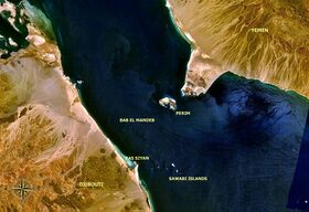
The Dact-el-Mayun, also known as the Western strait, the large strait, the large pass or the wide pass, is the western section of the Bab-el-Mandeb straits, which separates Ras Menheli, Yemen, on the Arabian Peninsula from Ras Siyyan, Djibouti, on the Horn of Africa. The strait has a width of about 16 miles (26 km) and a depth of 170 fathoms (310 m). The Yemeni island of Perim divides the strait into two channels, Bab Iskender and Dact-el-Mayun respectively.[1]
Near the African coast lies a group of smaller islands known as the Seven Brothers.
References
- ↑ William James Lloyd Wharton, John Phillips (1900), The Red Sea and Gulf of Aden Pilot page 230. Great Britain Hydrographic Office.
Lua error in Module:Coordinates at line 489: attempt to index field 'wikibase' (a nil value).
